Outdoor Historic Sites and Trails Across Texas
Texas history stretches across deserts, prairies, forests, and coastlines—and many of its most significant sites can still be explored on foot or by bike. Walk portions of the El Camino Real de los Tejas National Historic Trail, visit the towering San Jacinto Monument where Texas secured its independence, or cycle the 20-mile Lake Mineral Wells Trailway along a converted railroad corridor. Urban districts in Dallas, Austin, and San Antonio preserve architectural and cultural landmarks, while coastal routes connect key Mexican-American War sites from Sabine Pass to Palo Alto Battlefield.
The sections below highlight historic trails, battlefield parks, and preserved corridors that bring Texas history outdoors.
Urban Historic Trails in Dallas, Austin, and San Antonio
Texas’s major metropolitan areas offer walkable districts where architecture and public spaces tell layered stories.
In Dallas, the 3.5-mile Katy Trail follows a former railroad corridor from Uptown toward the American Airlines Center, connecting to downtown via pedestrian bridges. While primarily recreational, it passes near historic districts such as State-Thomas, known for its preserved late-19th-century residences. The West End Historic District includes 19th-century warehouses and sits near Dealey Plaza and The Sixth Floor Museum at Dealey Plaza, marking a pivotal moment in American history.
The Ronald Kirk Bridge spans the Trinity River as a pedestrian and cycling link between downtown and West Dallas parks. Around White Rock Lake, a 9.3-mile loop trail passes historical markers and remnants of early 20th-century infrastructure.
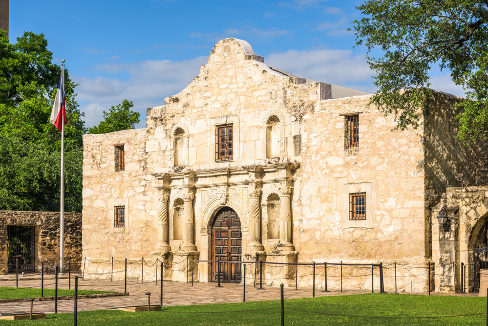
In San Antonio, the River Walk connects historic sites including the Alamo and Mission Reach trail extensions that link to several of the San Antonio Missions, a UNESCO World Heritage Site since 2015.
In Austin, trails along Lady Bird Lake provide access to historic downtown areas and landmarks such as the Texas State Capitol.
Accessibility Considerations for Historic Trails
Many Texas historic sites offer a mix of paved paths and natural terrain.
Wheelchair-Accessible Features
- San Jacinto Monument museum and observation deck (elevator access)
- Paved segments at Palo Alto Battlefield
- Sections of the San Antonio River Walk and Mission Reach Trail
- Portions of Lake Mineral Wells Trailway with flat crushed limestone surfaces
Primitive or Uneven Terrain
- Fort McKavett parade grounds and unpaved walking areas
- Remote El Camino Real trail fragments
- Battlefield prairie fields without paved pathways
Visitors should review site-specific accessibility information before arrival, particularly during rainy seasons when unpaved surfaces may become muddy.
Battle Sites You Can Visit: San Jacinto and the Texas Revolution
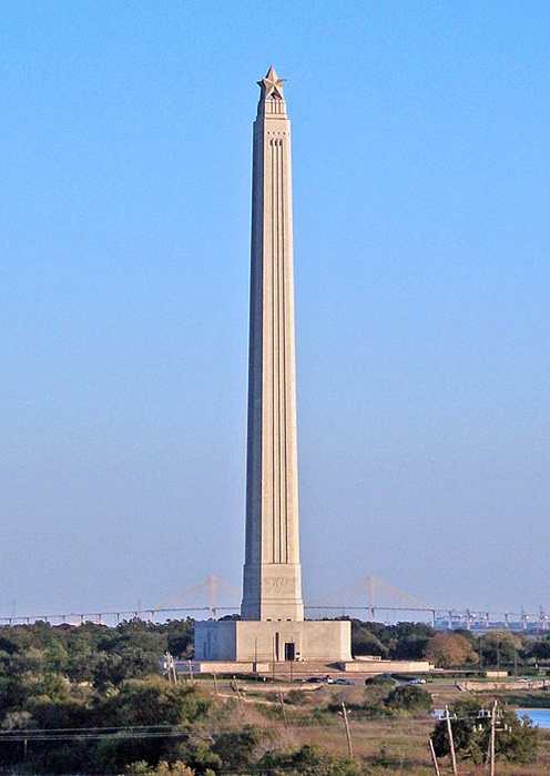
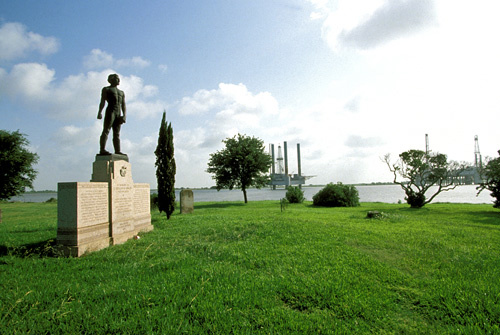
Where Buffalo Bayou meets the San Jacinto River stands the site of the decisive battle that secured Texas independence. On April 21, 1836, General Sam Houston’s army defeated Santa Anna’s forces in approximately 18 minutes at the Battle of San Jacinto.
Today, the San Jacinto Battleground State Historic Site spans more than 1,200 acres. Visitors can explore:
- San Jacinto Monument – At 567 feet tall, it is one of the tallest masonry columns in the world. A museum inside documents Texas history.
- Interpretive trails – Markers outline troop positions across the prairie landscape.
- Educational exhibits and seasonal reenactments – Highlighting the Texas Revolution.
Ground access is free; museum and elevator access to the observation deck require an admission fee.
Mission Trails and Spanish Colonial Routes Across Texas
Long before the Texas Revolution, Spanish missionaries and settlers traveled a vast network of routes across the region. The El Camino Real de los Tejas National Historic Trail, designated in 2004, traces approximately 2,500 miles from Mexico City through Texas to Louisiana.
Important waypoints include:
| Key Waypoint | Year Established | Modern Location |
| San Juan Bautista | 1700 | Near present-day Guerrero, Coahuila (across from Texas) |
| San Antonio de Béxar | 1718 | San Antonio |
| Los Adaes | 1729 | Near present-day Robeline, Louisiana |
Portions of modern Texas Highway 21 and segments labeled Old San Antonio Road (OSR) follow this historic corridor. In San Antonio, the trail connects directly to the city’s preserved mission sites, including Mission San José and Mission Concepción.
Texas Hill Country Heritage Sites
Beyond San Antonio’s missions, the Texas Hill Country preserves frontier forts, early settlements, and Revolutionary-era landmarks that remain accessible outdoors.
Fort McKavett State Historic Site, near Menard, preserves one of the best surviving examples of a mid-19th-century frontier fort. Established in 1852, the post once housed Buffalo Soldiers and protected settlers moving westward. Today, restored limestone barracks, officers’ quarters, and parade grounds allow visitors to walk the same open landscape once occupied by cavalry regiments.
Further south, Goliad State Park and Historic Site marks the location of Mission Espíritu Santo and the Presidio La Bahía. The park preserves Spanish colonial structures and commemorates the Goliad Massacre of 1836, a pivotal event during the Texas Revolution. Visitors can explore shaded grounds, reconstructed mission buildings, and interpretive trails that connect military and mission history.
These Hill Country sites combine preserved architecture with open prairie settings, making them ideal for travelers seeking historic immersion beyond urban centers.
Lake Mineral Wells Trailway and Other Rail-Trail Conversions
Across Texas, abandoned railroad beds have been converted into recreational corridors. The Lake Mineral Wells Trailway, stretching approximately 20 miles between Weatherford and Mineral Wells, follows a former rail line that once transported visitors to mineral water resorts.
The crushed limestone surface creates gentle grades ideal for cyclists, walkers, and equestrians. The broader state park system surrounding the trail includes additional hiking routes and access to Lake Mineral Wells State Park.
Notable features include:
- Historic railroad bridges along the route
- Equestrian-friendly segments
- Connections to former military training grounds at Fort Wolters
Other Texas rail-trails include the Campion Trail in Irving, a multi-segment paved path along the Elm Fork of the Trinity River.
El Camino Real and Cross-State Routes You Can Explore Today
The broader El Camino Real system evolved from Indigenous trade routes and later became a major Spanish colonial road linking missions, presidios, and settlements.
Travelers today can trace segments near:
- San Antonio – Spanish colonial architecture and mission sites
- New Braunfels – River crossings along the Comal and Guadalupe Rivers
- Nacogdoches – One of Texas’s oldest towns and a gateway toward Louisiana
Historic markers along Old San Antonio Road designate preserved portions of the route. While not continuously walkable, many sections are accessible via short interpretive trails or roadside pull-offs.
Coastal Trails from Sabine Pass to Palo Alto Battlefield
Texas’s Gulf Coast preserves important military and maritime history.
At Sabine Pass Battleground State Historic Site in Jefferson County, visitors can explore the site of an 1863 Civil War battle where Confederate forces repelled a Union naval assault. Interpretive signage outlines troop positions and coastal defenses.
Farther south near Brownsville, Palo Alto Battlefield National Historical Park preserves the site of the first major battle of the Mexican-American War in 1846. A paved loop trail (approximately 1.5 miles) and additional walking paths guide visitors across restored coastal prairie landscapes.
Nearby, Resaca de la Palma Battlefield includes additional walking trails and interpretive exhibits. Together, these sites illustrate how coastal conflicts shaped Texas’s modern boundaries.
Texas Historic Sites by Region
Texas’s size means its historic trails vary widely by landscape.
East Texas
- Pine forests and early Spanish mission sites
- El Camino Real segments near Nacogdoches
- Civil War and Republic-era markers throughout the Piney Woods
Hill Country
- Frontier forts such as Fort McKavett
- Spanish missions and presidios
- German immigrant heritage towns like Fredericksburg
Gulf Coast
- Sabine Pass Battleground
- Palo Alto Battlefield near Brownsville
- Maritime and port-related historic markers
Panhandle & High Plains
- Historic Route 66 corridors
- Adobe Walls battlefield site
- Fort Elliott near Mobeetie
This regional perspective helps travelers plan routes based on geography and historical era.